Wednesday, October 31, 2012

The Ghost Bus, The Finger and Phalli on an Arizona Highway

by Steve Reiss (Dalmdad Landscape Photography - www.dalmdad.com and https://www.facebook.com/Dalmdad.)

Outside Bullhead City, AZ: Union Pass is the highpoint on highway AZ68 as the road passes through the Black Mountains between the flatness of the Colorado River valley at Laughlin, NV/Bullhead City, AZ and the flatness of Golden Valley outside of Kingman, AZ. The Union Pass area is reportedly on the route of a haunted bus carrying 48 elderly gamblers ridiculously insistent upon making it from Phoenix to the Laughlin, NV casinos and that disappeared in the area in the early 1990's. The story first appeared in a blog entry by Jim Cook (the self-proclaimed 'Official State Liar of Arizona') at wickenberg-az.com, on October 27, 2003.

The original Cook version of the ghost bus story, long and twisted, says:
...
Bus 777 groaned onto I-40, rolled through Kingman, and found its way to Arizona 68, going west toward Laughlin. This was the home stretch. Impatient passengers began getting ready to exit the bus and make a break for the casinos, which were still a good 30 minutes away.
As the bus climbed the grade toward Union Pass, it really began losing power. Union Pass is a gateway through the Black Mountains, named for members of the Union Of Pioneer Pass Builders, who completed it in 1851.
Once through the pass, Arizona 68 swoops down to the Colorado River and the bridge to Laughlin. Joe [the driver] was having a hard time coaxing the bus the last few hundred yards to the summit of Union Pass.
Finally, he pulled onto the shoulder and told the passengers, “This is it, folks. The bus won’t go anymore.”
The passengers mutinied. Joe remembers Danny advancing on him, a malevolent look on his face. Danny’s eyes were slits of hot coals, and his pointed ears had turned red.
Joe remembers standing dazed beside the road as passengers pushed bus 777 over Union Pass and clambered aboard as it started down the west side, out of his view. The passengers had taken his shoes.
A tourist from Iowa, driving up toward Union Pass from the river, said he saw the bus speeding down the grade toward him. It went around a curve where a small hill hid it from view–and it never emerged.
When he got to the place where he should have met the bus, there was nothing–no bus, no skid marks, no debris, nothing.
That was the last sighting of bus 777 in this world. Lawmen combed the arroyos along Arizona 68 for days, but not so much as a skid mark or piece of chrome was ever found.
Another -more dramatic... and embellished- version of the ghost bus story appeared in 2010 at a website dedicated to UFO and Paranormal News, and included melodramatic detail:
Through a mire of heat, Joe recognized his bus, Number 777, now being pushed uphill by a gaggle of demons resembling his most recent passengers. At the helm of the vehicle was the old man-turned-Devil who had led the mutiny. An evil smile gracing his black lips, the senior citizen-cum-incubus glared back at the bus driver.
It was then Joe noticed the "icing on the cake." Those blue-haired bastards had stolen his shoes. Barefoot and confused, the coach operator watched as the troupe of fiends pushed the deceased bus to the crest of Union Pass.
 And of the bus,, also called the "Grim Weeper", the 2010 story reported that:
The vehicular apparition appears suddenly in your rear-view mirror, headlights ablaze, purportedly weeping molten chrome. Without warning, the behemoth devours your car, as you fight to retain sanity. Clearing your front bumper, the beast dissolves into the roadway illuminated by your headlights. The vacant seats inside your automobile become inexplicably occupied by ghostly passengers. Before you've wrangled your car to the side of the road, your otherworldly travel companions have vanished. You're left along the shoulder of a darkened highway, in the middle of nowhere, wondering if that signpost up ahead reads, "The Twilight Zone."

<< -  to Bullhead City ---------------------------------- to Kingman ->>

***
AZ 68 curves its way through and passes ...depending on the tilt of your imagination...a variety of provocatively shaped rock formations as it travels through the Black Mountain's Union Pass.  The Black Mountains are not actually black, nor are they actually mountains.  Well, ok, they actually are mountains.  The Black Mountain Range is of volcanic origin and runs 75 miles north-south just east of the Colorado River and peak out at Mount Perkins (5456 ft).  The Black Mountains are frequently seen rising above the green waters of the Colorado River.  Quiet little Oatman, AZ, the "free range burro" capitol of the world, is nestled up at about 2710 ft. on old US66 in a Black Mountain pass.  The "needles formation", which give the town of Needles, CA, its name, are not part of the Black Mountain Range; rather, they are part of the Mohave Mountain Range.
AZ68 Climbing Union Pass From the West


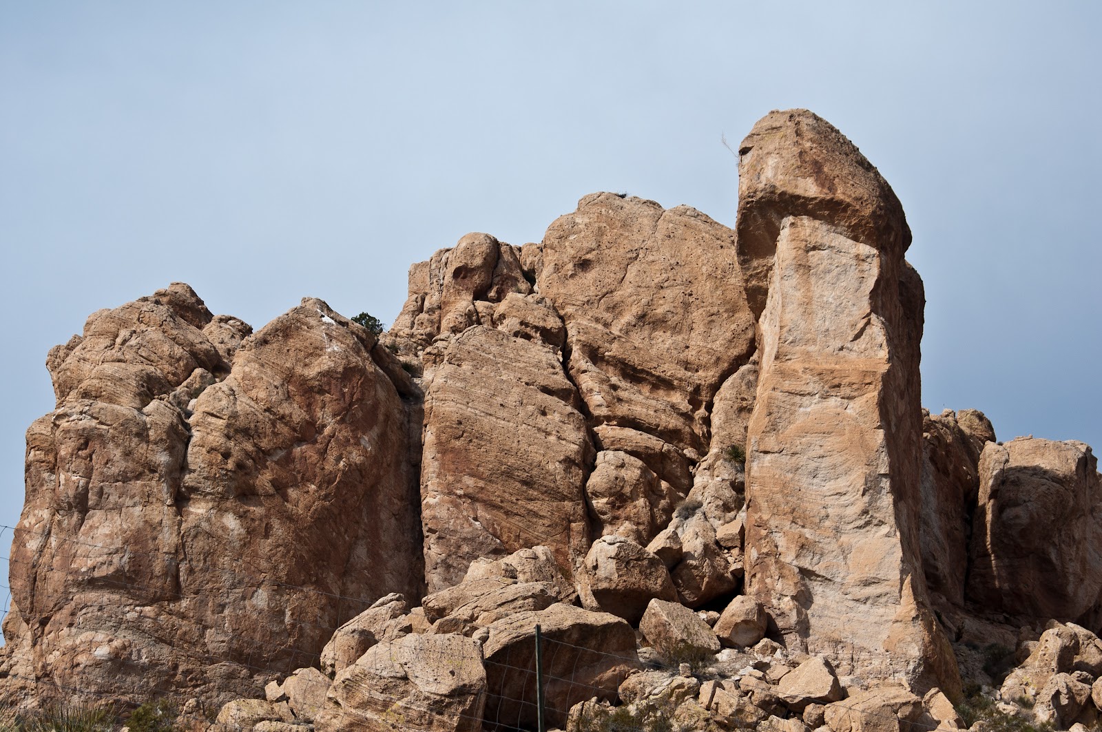
"The Finger" in the Distance
A first rock formation, first seen from quite a bit away, gives so-inclined viewers the impression of the exposed middle finger.  The flipped filthy finger flash becomes even more pointed at you as the road closes in on the rock formation.

As you get real close, you have an opportunity for a second impression.  It does not take a PHD in Geology or abstract art, to see nature flipping you off as you drive buy. Yes, Mother Nature is calling you a Mother $%#&.  The formation is called "Thumb Butte" on the Davis Dam 1:100,000 Quad Topographic Map of 1982.
"The Finger" of AZ68 Up Close

Thumb Butte from an entirely different angle with better lighting

***
A second rock formation right along the shoulder of the highway has an even more perverse appearance.

Even before I took the picture of this second formation, I certainly had a "naughty" subject in mind.  When I posted the picture on Flickr, I gave the picture the intriguing, but tame (or lame?), title of "Interesting?"  I did not give the picture any overtly suggestive or explicit title or id tags.  I don't want my Fickr stream labelled anything other than safe.  However, that did not stop someone else from taking a more explicit approach.


An "interesting" looking rock formation on AZ68

Not long (actually very shortly) after my version of the picture was posted to Flickr., someone outside my Flickr network saw the picture, tagged it "circumcision", and added it to her group "Circumcision."  The someone goes under the name "I wasn't circumcised - Lucky being a girl." 


***
All this action on a 27 mile strip of highway...


Sunday, October 28, 2012

Backcountry Falls - Not What You Might Think

by Steve Reiss (Dalmdad Landscape Photography - www.dalmdad.com and https://www.facebook.com/Dalmdad.)

A fictional tale about nature's order...

I remember that day vividly and horrifically. It was my saddest day ever in my 25 years as a park ranger.  

I was far into the rugged back country of the park (Anza-Borrego Desert State Park).  At Anza, I had packed and mounted my horse, Anzanita.  We then continued southward about 10 miles on Coyote Canyon Road to the area known as Turkey Track.  Turkey Track is ridiculously unstable (especially after rains), has sharp drop-offs, and ledges narrow and covered by loose slate or mud after storms.  Though the Track is open to true 4WD vehicles; I mean the type with high clearances, low gears, and wheel lock-outs, park guide books unanimously emphasize just how 'bad' this road is.  Practically, the Track is really only accessible by horseback riding, hiking, mountain biking, and burro trains.  Between Upper Willows and Middle Willows, where I was when it happened, is closed to all vehicle travel.  This three mile stretch is prime bighorn sheep watering areas.

The sounds of rocks sliding and falling does not take a park ranger with 25 years of experience to identify.  As I looked towards where I heard the rock slide, what I saw broke my heart.  I quickly grabbed my binoculars to double-check. I was right.  Rolling down the rocky and wooded hill was one of the park's bighorn rams.  Also rolling down the hill, following the ram, was a mountain lion.  Through my binoculars, I saw another mountain lion cautiously watching from the ledge as her mate and what I assumed to be their intended meal rolled down the hill.

All this was happening on the other side of Coyote Canyon and it would take me a while to get to a point where I could cross Coyote Creek at a shallow, slow flowing part and then backtrack to the point where the animals fell.  I recorded my coordinates on the GPS and started walking, leading 'Zita by her reins.  The animals on the other side of the canyon would surely be DOA by the time I reached them-  if not dead already.


***

Back at Majanga Spring, way up on Majanga Flat, we all looked up from drinking.  We heard the noise and the older among us knew what it meant.  I looked around.  Old Biggy and Smitty were not with the herd. They were known to randomly go out and butt heads, though Smitty conceded Old Biggy's dominance within our herd.


I sent out a call and Smitty's long yelp answered, but there was nothing returning from Old Biggy's drawling accent.  We all thought we knew exactly what happened.  Slippage is a risk we face every day as we move further and further uphill to protect ourselves against those predators with the guts to follow us.  We are typically the only ones that can make their way up so high on loose rocks and into protection.  But the higher we go, the greater the risk.  Indeed, when I was younger, I took a short slide down a steep canyon wall.  


It is a risk we all knowingly take because that is how we survive. 

***

I had finally reached the 'drop zone', for lack of better or more euphemistic term.  I released a couple of shots from my Browning rifle into the air to scare away any circling vultures, hiding coyotes, or surviving mountain lions to clear the area for my safety. 

The mountain lion's body was in much better shape than the ram's, though the mountain lion was just as dead as the ram.  The mountain lion just rolled down the hill, but the ram horns violently whipped the ram's head around, got caught on branches, and bounced the poor ram's head off rocks. What was left of the horns would not be going on display at any nearby museums and the ram's neck was obviously broke.  I guessed the ram died about 1/3 the way down and the mountain lion died on impact with the ground.

I opened a saddle bag and took out a small laser bar-code reader.  Luckily for me, this ram did not lose its collar on the way down.  I scanned the bar-code on the collar and a code showed up on the display.  The code meant little to me out here in the field.  The rangers at Park HQ in Borrego Springs kept track of the animal database.

I walked around trying to find a clear area out from under the tree canopy.  I found a spot and called park HQ on the sat phone.

"Hernandez, Animal Monitoring."

"Pico?  Flack here."

"Flack, you safe, mi hermano?"

"Yes.  I am at the spot."

"You made good time."

"I guess brother..."

"Does he have an ear tag?"

"No. He barely even has an ear.   Just a collar."

"OK.  Let me pull up the database.  Code?"

"C-O-0-1-7"

"An oldie.  Hmm.  'Old Biggy'...17 years old... born in-park...Parented three rams and two ewes.  Last vet check was about 6 months ago by Dr. Floyd."

"He looks pretty bad; the severe horn damage from the fall, some vulture feeding, and a broken neck.  I'm guessing the mountain lions chased him and these two took a nasty, unintended slide down a soft edge."

"OK.  I will prepare his file for closure when you get back.  Don't forget to take blood samples and of course the tracking collar.  Oh might as well take blood from both animals.  I will give you a break and not ask for a fecal sample."

"Muchas gracias on the fecal.  I will mark the coordinates of the site, post a marker, and take some pictures.  No reason to bury or extricate the carcasses.  I will leave them to the vultures; they have already been munching away."

"Remember its the natural order of things."

"I know"

"Be safe, hermano."

"Gracias."

I stood there looking at the two carcasses and I gave them what I thought was a proper blessing.

***
I slowly --carefully-- walked towards the edge of the cliff where my father slipped and fell to his death trying to escape from a mountain lion.  I laid down and looked across the valley.  My nose suddenly picked up the smell of a ewe.  I turned around and it was Santia, the alpha-ewe in our herd.  She walked over to me and hit my snout with hers.  That told me everything I needed to know. 


The New Alpha-male


Saturday, October 27, 2012

Over the Mountains and Through the Woods, to the Pacific Ocean we go...

 by Steve Reiss (Dalmdad Landscape Photography - www.dalmdad.com and https://www.facebook.com/Dalmdad.)

There are approximately 33 "road miles" between the inland Monterey County, CA, near ghost-town of Jolon and the Pacific Coast Highway (CA-1).  Those 33 road miles twist and turn and cover a mere 20 "as the crow fly" miles.

The 33 road miles are in no way an easy drive.  The switch-backs and alternating gas and brake pedalling will tire you...and then you will still have the strenuous drive north along the Big Sur coast to wherever you are going to call it a day.  However, it is all worth it.

Included in the 33 miles are:

1) visiting the remnants of Jolon, once a thriving community.  Now, not so much;

2) visiting Fort Hunter Ligget, known for the herd of free-range tule elk that roam the fort grounds;

3) visiting Mission San Antonio and its parish desert tortoise, also on the fort grounds;

4) driving through the fort's live fire practice range;

5) exiting Fort Hunter Liggett's back entrance, deep in the tree canopy of the Los Padres National Forest and beginning the trip over the Santa Lucia Range on Nacimiento-Fergguson Road, a road notorious for its driving challenges and views;

6) driving along the peak ridge of the Santa Lucia Mountains;

7) overlooking the Pacific Ocean and the cloud cover before coming down and merging with the Pacific Coast Highway.

This is pretty much an all day trip, but as I mentioned, well worth the time.

Over the next 7 weeks, we will be describing for you each of these segments.  We hope you enjoy and can take the drive some time.

The Drive Profile