Tuesday, December 25, 2012

Merry Christmas Tree Pass

by Steve Reiss (Dalmdad Landscape Photography - www.dalmdad.com and https://www.facebook.com/Dalmdad.)

 Christmas Tree Pass is in a corner of the Mojave Desert between Laughlin and Searchlight, Nevada.

The entrance to Christmas Tree Pass is located about seven miles west of Laughlin. The graded, dirt road of this pass runs through a ruggedly beautiful canyon rich with wildlife and petroglyphs. The canyon is part of Lake Mead National Recreation Area, and the trek via car from NV State 163 to NV State 95 takes about 45 minutes. About two miles in from 163, is an unmarked side road to Grapevine Canyon. The lush plant growth in this canyon is in sharp contrast to the stark, surrounding hillsides. A short hike up Grapevine Canyon, visitors will find a small desert spring which flows almost year round. This spring not only allows certain plants to grow here, but also provides a water source for bighorn sheep and other animals. The petroglyphs on the canyon's sheer rock walls also indicate the presence of ancient inhabitants as early as A.D. 1100. Spirit Mountain, the highest peak in the Newberry Mountain range, rises to an elevation of 5,639 feet and looms above the canyon. This mountain, considered the beginning of creation, is a sacred place to Indian tribes in Southern Nevada and has become the first Indian land in the state to be placed on the National Register of Historic Places.
Here are pictures of the area from when I was there in 2011...

Christmas Tree Pass, Southern Nevada (heavily processed/experimental)

Christmas Tree Pass, Southern Nevada

Christmas Tree Pass, Southern Nevada

Christmas Tree Pass, Southern Nevada

Christmas Tree Pass, Southern Nevada

Christmas Tree Pass, Southern Nevada


Christmas Tree Pass, Southern Nevada
 

Monday, December 24, 2012

Bighorns of the Colorado River Wilderness...

by Steve Reiss (Dalmdad Landscape Photography - www.dalmdad.com and https://www.facebook.com/Dalmdad.)

As we have written about before, spotting bighorn sheep can be a major challengeThe sheep stand on rock out-crops high in the mountains, safe from their predators.  Typically, if you are lucky, at most, you will get to see one or two at a time.

That was why I was shocked one day, to see a herd of bighorns just "hanging out" in the wilderness of the Black Mountains of Arizona (the same Black Mountains referred to here) between US93 and the Colorado River, below Hoover Dam and near Willow Beach. I was able to drive up pretty close to them, but they were on the other side of tall earthen berm that I did not exactly feel comfortable trying to completely cross, especially alone and carrying my camera equipment.


Note this one has an ear-tag for ID.
  It was in this very area, in 2011, that we saw a lonely burro, trying to hide in the shade on a hot day.  Today, I waved to a passing car to tell them they should stop and see the bighorns, but apparently not everyone find the bighorns as interesting as us.


Though the sun was in an poor photographic position, the bighorns were not in the least bit shy.


Monday, December 17, 2012

Outragous Gas Prices in Needles, CA

by Steve Reiss (Dalmdad Landscape Photography - www.dalmdad.com and https://www.facebook.com/Dalmdad.)

Sunday, November 7, 2004: Needles, CA: I was driving cross-country to California for the first time. It had been about 4 days since I left Memphis, TN.  I had passed through Arkansas, Oklahoma, the Texas panhandle, New Mexico, and Arizona; so far, about 1500 miles.  I spent last night in Kingman, AZ.

After breakfast in Kingman, I headed west on the I-40.  Not knowing any better, I stopped in Needles, CA, that morning for the same reason most people stop there and have stopped there since the Dust Bowl years of the 1930s. Needles is the first major population center in California (current population 5600, 1930's population 3100) after the long, desolate, 60 mile drive west on I-40 from Kingman, AZ (and US66 prior to the construction of I-40) and the last reasonably populated place along I-40 before the scarey "No Services Next 35 Miles" sign.

I don't reme
mber how much gas cost on that Sunday in 2004, when I stopped for a fill-up in Needles, but I seem to remember that the gas price was
absurdly expensive.  The emotional shock of spending so much on gas that morning left a long-time negative taste in my mouth concerning Needles. 

***

Now, many years later, I am a much more seasoned travelerI have learned, like many of the residents of, and visitors to, Needles (see here, here, here) themselves, to purposely drive the few extra miles to avoid having to gas up in Needles and make it to Mohave Valley or Bullhead City, Arizona where gas is historically about 40 cents to a dollar a gallon cheaper.  The gas price situation in Needles is so crazy, that in September, 2012, when I asked my friend in Needles how much gas was there, she did not know.  She told me the gas price in Bullhead City, AZ and said add a dollar and that is probably what it is in Needles.

This is when I began to fully appreciate the immediate personal and economic impact that CA state and county gas taxes, coupled with Needles' unique position on the I-40 between Barstow, CA, and Kingman, AZ, create the opportunity for, or at least the appearance of, price gouging. 

Historical differences in gas prices between Needles, California, and the rest of the US can be seen in photos of Needles' gas stations' price boards posted on Flickr over the years. 


CA Gas price data from here
US Gas price data from here 
 
Date Needles CA US
5/8/2005 3.09 2.56 2.23
5/26/2006
3.79 3.32 2.89
6/14/2006 3.89 3.22 2.91
12/28/2006 3.29 2.61 2.34
1/4/2007 3.89 2.61 2.33
4/2/2007 3.79 3.23 2.71
3/24/2008 4.09 3.60 3.26
5/21/2008 4.69 3.95 3.79
6/15/2008 5.19 4.58 4.08
9/25/2008 4.59 3.73 3.72
11/15/2008 3.29 2.37 2.07


Where exactly is Needles?  It is on the California side of the Colorado River and a historic stop along US66 (now I-40).  Before the I-15 and its predecessor highway (US91/466) where built, those driving from Vegas to LA had to take the US95 (gray line) from Vegas to Needles to catch the US66/I-40.


Needles Locator Map


Sunday, December 16, 2012

Over the Mountain ... (Part 7 of 7): Coming down and merging with the PCH

by Steve Reiss (Dalmdad Landscape Photography - www.dalmdad.com and https://www.facebook.com/Dalmdad.)

Nacimiento-Fergguson Road (NFR), heading down to the Pacific Ocean: The last bits of the NFR experience are downhill from the high-country of the Santa Lucia Range to sea level at the Pacific Ocean and the Pacific Coast Highway (PCH, CA-1) in rugged Big Sur country.


Views towards the Pacific Ocean from the high-country


**

Views of the coastal parks, as NFR winds its way down to sea level.


PCH heading north towards Carmel along Big Sur Coast


PCH heading south towards Cambria along Big Sur Coast

Looking down on PCH


**

When you reach the Pacific Ocean, you can either head south towards the Piedras Blancas Elephant Seal Preserve and Cambria or north towards Big Sur, Carmel, and Monterey.

A recommendation would to head south just a little bit to the town of Gorda, overlooking the Pacific Ocean.  A wonderful restaurant, the Whale Watcher Cafe, is waiting for you.


Though the Whale Watcher gets some pretty awful reviews at yelp, we never had a bad experience there.  Indeed, this was one of the first places we ate at when we drove cross-country for the first time.  Yes, the prices are steep, but this is a very remote location and we never left feeling we were extorted.  The burgers and the nachos are great and can be eaten while looking out for passing whales.

**

Tuesday, December 11, 2012

Impressed by a Rock-Climbing Kid!

by Steve Reiss (Dalmdad Landscape Photography - www.dalmdad.com and https://www.facebook.com/Dalmdad.)

Saturday, December 8, 2012: Cyclops Rock, Joshua Tree National Park:  We have seen plenty of rock-climbers going up and down the rocks at Joshua Tree.  This particular part of the park has a lot of major magnets to climbers.

Random Rock Climbing Team
***

Today, I was extremely impressed with a mere 12 year old coming down Cyclops.  Here are a bunch of views of him.  His name is Daniel.


Sunday, December 9, 2012

Over the Mountain... (Part 6 of 7): Driving above the sea layer in the Santa Lucia Mountains

by Steve Reiss (Dalmdad Landscape Photography - www.dalmdad.com and https://www.facebook.com/Dalmdad.)

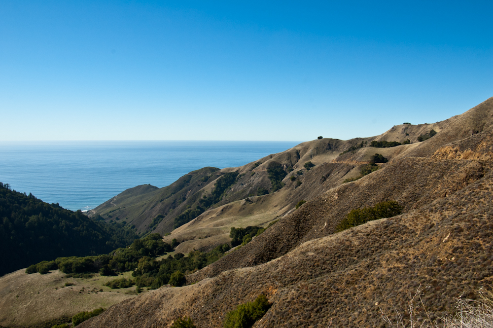
Nacimiento-Fergguson Road (NFR), high in Los Padres National Forest: After driving the dark, damp, forest floor, NFR begins its climb towards its summit at 2780 feet.  NFR is well paved and maintained, but is very winding and has precipitous drops at almost every turns.  There are no guard rails. The turn-off for Cone Peak Road, leads to some fantastic ocean sunsets.  However, Cone Peak Road may be closed due to weather from November to May.  The turn-off for Coast Ridge Trail, near the turn-off for Cone Peak Road, leads substantially parallel to the Pacific Ocean (i.e., north-south), along the crest of the range.

In October, 2009, the Mano Seca Group installed a bench near the top of the western slope of Nacimiento-Fergusson Road. A large turnout on the road provides easy parking; an opening in the roadside fence provides a path down to the bench.  The Mano Seca Group has a guerrilla reputation, as federal and state park services do not take kindly to the construction of unauthorized structures on park grounds.

Looking down one of the canyons from above the sea layer on NFR


Road cut for NFR clearly visible.


Road cut for NFR clearly visible.


Road cut for NFR clearly visible.


Road cut for NFR clearly visible as it circles the knob above the sea layer.


Burnt out trees contrasting with the high elevation greenery.


View across the Santa Lucia Range


Another view across the Santa Lucia Range


Road cut for NFR clearly visible along with the Pacific Ocean.

Sunday, December 2, 2012

Over the Mountains... (Part 5 of 7): Exiting Fort Hunter Liggett's back Entrance

by Steve Reiss (Dalmdad Landscape Photography - www.dalmdad.com and https://www.facebook.com/Dalmdad.)

Compared to the wide open space of FHL's Jolon gate,FHL's NFR gate is remote and tucked into the forest.  You may even--for a moment--feel bad for the guard posted here in the middle of no where.

This photo is courtesy Doctor Love 415


Nacimiento-Fergusson Road (NFR) is a popular highly-scenic, but tough to drive, Monterey County road.  As mentioned in an earlier post in this series, NFR begins at Mission Road in Fort Hunter Liggett near the truss bridge over the San Antonio River.  The Road ends 14 miles later at the Pacific Ocean, after twisting its way through the Los Padres National Forest and up and down the Santa Lucia Mountains.  Coast Road, which runs parallel to the Santa Lucia Range and the Pacific Ocean, crosses NFR about 9 miles from the NFR Gate of Fort Hunter Liggett. NFR is the only road that crosses the SL Range.

After the NFR gate, you are in pure forest country; trees, trees, and even more trees.  If you want to see fall in California, this is a good place to look.  A lot of visitors to California comment that we do not have a fall season.  That is not true, you just need to know where to look for it.  You won't find fall standing on the Newport Pier, where bikinis are worn year round or at the beach in San Clemente.

Scenes from fall in the Los Padres National Forest....


What people say about Nacimiento-Fergusson Road:

one of those roads that requires some serious planning to actually get to for most people.
***
If I never see Nacimiento-Fergusson road again, it will be too soon. Let me explain.,,,For the first few miles, the Nacimiento-Fergusson road was very nice. It took us through some fields, then we wound our way through the woods. But then, all of the sudden, we were climbing a cliff, the road got more narrow, and I lost my mind. I was shaking, driving 10 mile per hour, and basically behaving like a lunatic. They don't have mountains like that in Detroit! Fortunately, Margaret is a little cooler than I am and she ordered me to stop at a scenic viewing spot and she took over. We got a few pictures from this drive, but mostly, we were both completely freaked out. The road was too narrow for us to turn around, and it just kept getting scarier ahead. Eventually, however, we made it to the coast without Nacimientoing and we had one of the best breakfasts I've ever had.
*** 
 ***
***