Saturday, September 26, 2015

On Forced Bighorn Relocation and Death in Arizona...

by Steve Reiss (Dalmdad Landscape Photography - www.dalmdad.com and https://www.facebook.com/Dalmdad.)

 I reproduce the text of the article, because headlines and links disappear over the years.

As we consider most bighorn-sheep related news to be important, we archived the report here.

Commentary on the article will come from us soon.
***
http://www.foxnews.com/science/2014/03/23/bighorn-sheep-conservation-arizona-mountain-lion-catalina/
***


Deaths of bighorn sheep in Arizona spark controversy over conservation effort

    CatalinaBighornsheep.jpg
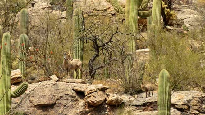
    This photo, obtained by FoxNews.com, shows part of the bighorn sheep herd relocated from Yuma to the Catalina mountains, just north of Tuscon. (George Andrejko/Arizona Game and Fish Department)
Some animal welfare groups are pushing for an end to the project, but wildlife officials say the conservation effort is not a failure and expect the projected $600,000, three-year plan to result in greater numbers of bighorns in an area where they once co-existed with mountain lions for centuries.


The issue, say Arizona wildlife officials and biologists, is a complex one.

Bighorn sheep, a gregarious, herd-forming species, once thrived in large numbers across the western U.S. until their population dropped dramatically over the past 100 years -- for reasons biologists continue to study, such as disease, fires or loss of water source. Wildlife officials in Arizona estimate the current count to be around 6,000 in the state, and they are working with conservationists to rebuild a herd that disappeared from the Tucson range in the 1990s.

Last November, the Arizona Game and Fish Department implemented the first phase of a three-year plan to transplant the creatures from the Yuma area into the Catalinas, where they once lived. Wildlife officials in the state said they spent $150,000 -- none of which was taxpayer money -- to catch 31 bighorns by helicopter, place satellite transmitter collars on them and transport the herd to the Santa Catalina Mountains just north of Tucson.

Four months later, 15 of the bighorns had been killed by mountain lions that thrive in the area -- leaving some animal welfare advocates to question whether such a plan was prudent on the part of an independent panel formed by state wildlife officials.


The Catalina Bighorn Advisory Committee -- comprised of groups such as the Arizona Desert Bighorn Sheep Society, the Wilderness Society and the Center for Biological Diversity — had recommended that officials not kill any mountain lions prior to the transplant of bighorns.

After nearly half the bighorn herd was killed, state wildlife officials in turn killed two mountain lions -- leading to protests by individuals who claimed the big cats should not be targeted for acting as natural predators in the wild.


 An editorial published last December in the Arizona Republic posed a question at the heart of the controversy: "Re-creating a bighorn population in the Catalina Mountains is a good goal that may result in the loss of some individual animals. How many are too many? When does the project cross the line from ambitious and worthy to sacrificial and cruel?"


The Arizona Game and Fish Department and its supporters stand by the transplant decision, although Jim Paxon, special assistant to director Larry Voyles, said "in hindsight, we should have taken out some mountain lions."


 "Conservation of wildlife is never easy, never quick and is often what biology professors call messy," Paxon told FoxNews.com. He said the plan moving forward is toassess areas in the Catalinas where the bighorns have the greatest chance of survival and place additional sheep there in the fall. He said the hope is that the remaining bighorn transplants and their lambs will move toward the new herd. Paxon also said some mountain lions near the determined location will be killed, but stressed that officials are not planning a "wholesale removal of mountain lions across the Catalinas."


 "All we’re doing is removing mountain lions that prey on bighorn sheep in the best habitat area for those sheep," he said, adding that the mountain lion population is "not only healthy, it's thriving and expanding."


 Critics, however, say the current plan should be stopped immediately.


 "I don’t think that they really thought this out," said Ricardo Small, of the group Friends of Wild Animals, adding that, "this decision was pushed by hunters."


 "The response to mountain lion killings of bighorn sheep has been to kill the mountain lions.


 That's a mistake," Small said. "When competition among mountain lions is removed, the litter sizes of the females increase and the result is more mountain lions than were there to begin with."


 "I think that the Arizona Game and Fish Department should stop this program completely. It's a waste of bighorn sheep and a waste of mountain lion."


 But supporters of the group claim it's premature to abandon efforts to rebuild a population that once thrived in the Catalinas.


Kevin Murphy, conservation director of the Wild Sheep Foundation, called the bighorn deaths "frustrating," but said he was fully supportive of the plan in place. He also noted that the transplanted herd successfully birthed lambs and said more are expected in the coming months.

"Wildlife management is not a perfect exact science," Murphy told FoxNews.com. "You can't measure the success yet. It’s designed to be a three-phase release."
***

Tuesday, January 20, 2015

Fantastic Once in a Lifetime Luck in the Virgin River Gorge

by Steve Reiss (Dalmdad Landscape Photography - www.dalmdad.com and https://www.facebook.com/Dalmdad.)

January 8, 2015: On I-15, between Littlefield, Arizona and the Utah state line.

To me, the Virgin River Gorge is a jaw-dropping spot.  I-15's four lanes twist their way through the gorge, the highway elevated above the Virgin River.  This portion of I-15 cuts through the Arizona Strip, a remote portion of Arizona, more accessible to Salt Lake City than to Phoenix.

To photographers and tourists, the Virgin River Gorge is a challenge.  The challenge is, the gorge is so narrow the highway lacks shoulders or pull-off's.  So, there is no stopping or even slowing down to capture a photo in the gorge.  I find the inability to photograph this spot depressing.


However, today I was graced with good luck.  I had he opportunity to view the gorge and take photos that few tourists ever can.  Personally, I did not care about the uniqueness or whether others had been able to photograph here.  I only cared about me being given the opportunity to photographically capture one of the most captivating spots I have ever passed through.  


So, how did this lucky opportunity arise?

I woke up about 6:30AM.  I tried to take a shower in my Virgin River Hotel and Casino room.  I was frustrated over the lack of hot water.  You may not know this about me, but I love the hot shower.  I am one of those persons that comes out of the shower lobster red.  But not this morning…I had to subject myself to the cool water of the room’s shower and then race to get dressed.

I topped off my gas tank and ice chest at a gas/food market immediately next to the highway interchange.  Sure I cannot drive without gas, but more important is my precious life elixir Coke will not remain cold if my cooler is not topped out.  The price of ice I do not recall; the price of gas of course keeps a spot in my mind and journal as gas prices are falling at the moment.  The gas did seem like a bargain at the $2.40 range.  I would find out in a couple of days that just a few hundred feet (in other words not even a mile) south of the highway exit I kept using to get on and off I-15, gasoline was about $1.97, about $0.50 gallon cheaper than across Pioneer Drive from the Casino and right next to the highway.   


I left Mesquite, Nevada around 7:15 AM for Cedar City, Utah.  I was interested in seeing if there was any way to get any pictures by driving through the I-15 gorge.  I took Hillside Driver east out of Mesquite.  Hillside generally runs parallel to I-15 for a few miles east of Mesquite.  As a historical side note,  Hillside Drive was US91, the historical route from the Utah Territory to the Las Vegas Valley of the Nevada Territory.

A Hillside Drive turnoff (Scenic Road) takes you on a five-mile drive towards some hills and across a small slice of the Virgin River.  The narrow slice of this typically scenic river was remarkably unscenic and therefor I did not even stop for a picture.  

I drove back to Hillside Drive and headed north/east.  Hillside veers away from I-15 for a few miles as the two roads become separated by some rocks known as the Virgin Moutains until I-15 becomes visible again and Hillside prepares to cross I-15 at Littlefield, AZ, heading north into an ancient Joshua tree forest.  I got on the 15, heading north towards Salt Lake City, well really Cedar City.  I accelerated up to the 70 mph or so local speed, turned up the music and prepared to drive through the gorge.

But not this morning.  It was not very long before I was slowing down to a stand still.  I was stopped behind a parked escort truck.  


I was indifferent at the moment as to whether or how long the delay would be.  The unique opportunity this moment was posing did not immediately hit me in the face.  But then, I was like...huh?  How long will I be here?  Who cares, it is picture time.  I unpacked my camera and got out of the car.

Looking up the North Side Wall of the Gorge
Llooking back towards Littlefield and looking south. You can see how the Gorge is in the shadow.


I heard some noise.  Though hard to see, there is a rock slide going on.

Hard to see worker up on he top of the southern wall of the Gorge.

Easier to see man hanging from the gorge

Here Comes Everyone Else - Off to St. George we go!
***


Wednesday, January 14, 2015

One of These Things is Not Like the Others

by Steve Reiss (Dalmdad Landscape Photography - www.dalmdad.com and https://www.facebook.com/Dalmdad.)

January 10, 2015: North of Dyer, Nevada is the Fish Lake Valley.  It is a remote place, just east of the White Mountains, which form the border between Nevada and California.

It is a rugged place, and I presume filled with educated folks.  However, somewhere, sometime, someone made a mistake...


***

Tuesday, November 25, 2014

Spur of the Moment Trip To Joshua Tree National Park and Bighorn Sheep

by Steve Reiss (Dalmdad Landscape Photography - www.dalmdad.com and https://www.facebook.com/Dalmdad.)

It was very spur of the moment that I decided to go an overnight trip to the desert.  We had pretty much just gotten back from China.  But, I got some sudden inspiration to go to Roy's to get some subject matter on the novella/short story I am writing that takes place at Roy's in Amboy.  As I am so infrequently inspired, I forced myself to take advantage of the moment.

Before entering Joshua Tree NP, I decided to browse one of the few gift shops outside the park in Joshua Tree Village near the intersection of CA-62 and Park Blvd.  I was looking for something screaming "bighorn" sheep.  All I could find was a measly ceramic coaster for $8.


This coaster, though hand made in Arizona, cost substantially less than the jade bighorn sheep we brought back from China.

I headed down Park Blvd to the Park's West Entrance.  I pulled out my wallet to prepare to pay the admission fee, but the ranger told me that because it was Veteran's Day, park admission was free today.

Then, not 50 yards in the park and from the park entrance, I saw a ranger with binoculars to his eyes looking out into the field.  And then, like a treat from above, in a clearing to the west, was a large herd of bighorns; our favorite animal.  I think that this was the first time I ever saw any bighorns at Joshua Tree.

I counted about 25 in the herd.  The official Joshua Tree website says that there are only about 250 bighorn sheep in the 1200+ sq. miles that the park covers.  So, this herd was nearly 10 percent the entire park population seen at one time.  What a great sight!.


Bighorn Herd, Seen Nov. 11, 2014


***

Sunday, November 23, 2014

The Zzyzx Phenomena

by Steve Reiss (Dalmdad Landscape Photography - www.dalmdad.com and https://www.facebook.com/Dalmdad.)

(Note: See our new Desert Studies Center/Zzyzx image album at Flickr.)

Anyone who has looked out their car window while driving in the dull desert between Barstow and Baker on the I-15 have probably noticed the sign for Exit 239 - Zzyzx Road.  The name is so darned mysterious and intriguing that the short road has become a strong magnet to back road and desert explorers.  Zzyzx Road's popularity has led it to even have its own Yelp entry.

The mystery and intrigue may stem from (or have led to) any or all of the following:

  1. The name Zzyzx and the history of the exit area;
  2. The origin of the name Zzyzx;
  3. Two similarly named films produced in the area at around the same time;
  4. The series of songs and albums that have some form of Zzyzx in their title;
  5. Captain Zyzzx (book);
  6. The Narrows (book);
  7. Bighorn Sheep Spotting
 1. The Name Zzyzx and the history of the area (from wiki-footnotes removed).
Zzyzx, California /ˈzzɨks/, formerly Camp Soda and Soda Springs, is a settlement in San Bernardino County, California. It is the former site of the Zzyzx Mineral Springs and Health Spa and now the site of the Desert Studies Center. The site is also the location of Lake Tuendae, originally part of the spa, and now a refuge habitat of the endangered Mohave tui chub.

Zzyzx Road is a 4.5-mile (7.2 km) long, part paved and part dirt, rural collector road in the Mojave Desert. It runs from Interstate 15 generally south to the Zzyzx settlement. The nearest town is Baker, California, 7 miles (11 km) north on I-15. Las Vegas, Nevada is the nearest major city, about 100 miles (160 km) northeast.
Soda Springs, a natural spring, has long seen human activity. The area was a prehistoric quarry site, and projectile points and rock art can be found in the area. The Mojave Road ran past the spring, as did the Tonopah and Tidewater Railroad. Remnants of a wagon road stop and railroad artifacts are readily seen. Evaporative salt mining and mill sites can be found here as well.
Curtis Howe Springer established the Zzyzx Mineral Springs and Health Spa in 1944 at the spot, which was federal land, after filing mining claims for 12,000 acres surrounding the springs. He used the springs to bottle his water and provide drinks for travelers through the hot desert. Springer also imported animals from around the country to attract more families to visit his ranch. He used Zzyzx until 1974, when he was arrested by the United States Marshals for misuse of the land as well as alleged violations of food and drug laws, and the land was reclaimed by the government. Since 1976, the Bureau of Land Management has allowed California State University to manage the land in and around Zzyzx. A consortium of CSU campuses use it as their Desert Studies Center.
 2, Origin of the word  Zzyzx (from wiki-footnotes removed):
The made-up name Zzyzx was given to the area in 1944 by Springer, claiming it to be the last word in the English language.
Word Ways magazine verified the source of the lexicography as an undated San Bernardino County map published by the Automobile Club of Southern California. The magazine characterized Zzyzx Springs as "a hydrologic feature and a privately owned spa catering to the senior citizen, about 8.5 mi (13.7 km) south of Baker on the western edge of Soda Dry Lake, off the abandoned right-of-way of the old Tonopah and Tidewater Railroad."

Zzyzx was approved as a place name by the United States Board on Geographic Names on June 14, 1984. As is the case with the road, Zzyzx, California, is the USBGN's lexicographically greatest (alphabetically last, at least in English alphabetical order) place name.

In this sense, Zzyzx is very similar to that other phrase popular in the desert, in Road-Runner/Coyote cartoons, "Acme", which was intended to be first in any directory:
The name Acme became popular for businesses by the 1920s, when alphabetized business telephone directories such as the Yellow Pages began to be widespread. There were a flood of businesses named Acme (some of these still survive). For example, early Sears catalogs contained a number of products with the "Acme" trademark, including anvils, which are frequently used in Warner Bros. cartoons
....Whenever we played a game where we had a grocery store or something we called it the ACME corporation. Why? Because in the yellow pages if you looked, say, under drugstores, you'd find the first one would be Acme Drugs. Why? Because "AC" was about as high as you could go; it means the best; the superlative.— Chuck Jones
3. The Battle of the Zzyzx Films.

There are two films with names similar to the area.  They are Zyzzx and Zyzzyx Road.  Note that Zyzzyx Road purposely misspell's Zzyzx.

The producers of these two movies got into a comments battle on the IMDB boards.  I hope to summarize the battle at a later time.  However, the crux of the battle was over who's movie was better or worse.


Zzyzx (renamed Burned for some reason) and Zzyzx Road (ZR) are very different movies (summaries from IMDB).

Zzyzx is Zzyzx, the road, may lead to nowhere, but three people find themselves baking in a desert of murder, mystery, manipulation and greed when the legendary road becomes the place where their destinies collide.
IN ZR, :The family man accountant Grant travels to Los Angeles and meets the lascivious "Lolita" Marissa in a casino. While in the motel with Marissa, her violent ex-boyfriend Joey surprises them on the bed, hits Grant on the head, but he kills Joey. Grant brings Joey's body to bury in the desert Zyzzyx Road, but after digging a grave, he finds that the body is missing in the trunk of his car. Grant chases Joey with a shovel in the desert, and when he finds the man hidden in a abandoned mine, Joey discloses a secret about Marissa.
More recently, a movie called The Last Resort (2009) was filmed on-site at the Desert Studies Center (see pictures)The swings, the Castle, and the Pool Enclosure Wall, at the DSC are predominantly shown in te movie.  However, the movie is supposed to take place in Mexico and there is no reference to Zzyzx.

On a stranger tone, a B-movie style internet series FemVamp filmed an episode at the exit.

***
4, The Zzyzx Songs...

On Spotify.com, I came across a number of songs with Zzyzx in their title, none of which seem to have anything to do with the road.

The list includes:

* the song Zzyzx Rd, by Stone Sour.
* Zzyzx Scarecrow", is a song by the band Stavesacre 
* Zzyzx (album), an album by Zeromancer
* Zzyzx - a song and album by Alphadiabetic - this song is an instrumental.
* ZZYZX - a song by In Desolation, off the album Off with their heads.
* Zzyzx Road, a song by Ivan Ives


***
5. Captain Zyzzx (book);
Captain Zzyzx is a book by Michael Petracca.

Despite the prominence of Zzyzx in the book's title, Zzyzx only plays a minor role in the story line. However, the book does refer to the compelling feeling passers-by have to stop and explore Zzyzx Road on their way to or from Vegas.

6. The Narrows (book)
The Narrows is a crime novel written by Michael Connelly.

A significant scene in the book takes place at Zzyzx Road.  While I don't want to give spoilers, it is my opinion that it is unlikely what is said to have happened at Zzyzx Road in the scene could.

7.  Bighorn Sheep

Zzyzx Road in the area before the Desert Studies Center is a prime location for spotting bighorn sheep when they water up and mate in April.  I have been there many times to see the bighorns.

***
 If you have a Zzyzx story, let us know!

Monday, November 17, 2014

Imperial Guardian Lions Guarding What and With Which Paw?

by Steve Reiss (Dalmdad Landscape Photography - www.dalmdad.com and https://www.facebook.com/Dalmdad.)

Amboy, CA - Having traveled throughout China and Taiwan, I have learned about Chinese architecture.  One of my favorite aspects of Chinese architecture are imperial guardian lions (Mandarin: shi).

I was surprised to see two guardian lions guarding much not of anything out in the desert just outside "downtown" Amboy on the south side of US66.  This is the male, the female is to the left of the male outside the frame, as she should be.


Imperial Guardian Lion with Amboy Crater in Background
If you did not know much about imperial guardian lions, you would not have noticed the apparent mistake in this statue.  You need to look close.


As can be seen here, the male lion has its left paw resting on the ball.  This is incorrect.  As said at Wikipedia:
The male lion has its right front paw on a type of cloth ball simply called an "embroidered ball" (xiù qiú, 绣球), which is sometimes carved with a geometric pattern (coincidentally, resembling the figure called "Flower of Life" in the New Age movement).
Here is a photo of a male imperial guardian lion statue photo taken in Wuhan, China.


Ball is under right paw, closest to door (Wuhan, China).


So, whoever went to the trouble of putting those guardian lions out in the Amboy desert, they just quite missed getting it correct.  Oh...as mentioned above, there was a female guardian lion to the left of the male lion, as these lions always come in pairs.  However, I did not notice whether the sculptor had the young lion under the wrong paw of the female.  As can be seen in this photo from the Forbidden City in Beijing, the female lions has a cub under the closer (left) paw to the male.

 
Lion Cub Under the Left Paw of Female Guardian Lion


Guess I will have to go back to Amboy some time to see if they got this correct.


Saturday, November 15, 2014

What Does Cal Trans Know, Anyway?

by Steve Reiss (Dalmdad Landscape Photography - www.dalmdad.com and https://www.facebook.com/Dalmdad.)

 Along US66, Mojave Desert, CA - A few weeks ago we actually had some rain.  I thought I heard or read somewhere that portions of US66 around Amboy were washed away and would not be repaired for a while.

I wanted to go to Roy's Cafe for a photo shoot, so I checked the Cal Trans website and was informed that US66 was open.


Unfortunately, Cal Trans has no clue about its own highways and their status.


US66 East at Ludlow, CA
US66 East at Kelbaker Road
US66 West - Immediately west of entrance to Amboy Crater
So, basically, Amboy could only be accessed via Kelbaker Road from I-40 or Amboy Road via 29 Palms. 

Anyway, at least Amboy was accessible and I managed to get some nice, original prints (coming soon).