Showing posts with label anza-borrego. Show all posts

Thursday, April 3, 2014

Want Chips With that Dip?

by Steve Reiss (Dalmdad Landscape Photography - www.dalmdad.com and https://www.facebook.com/Dalmdad.)

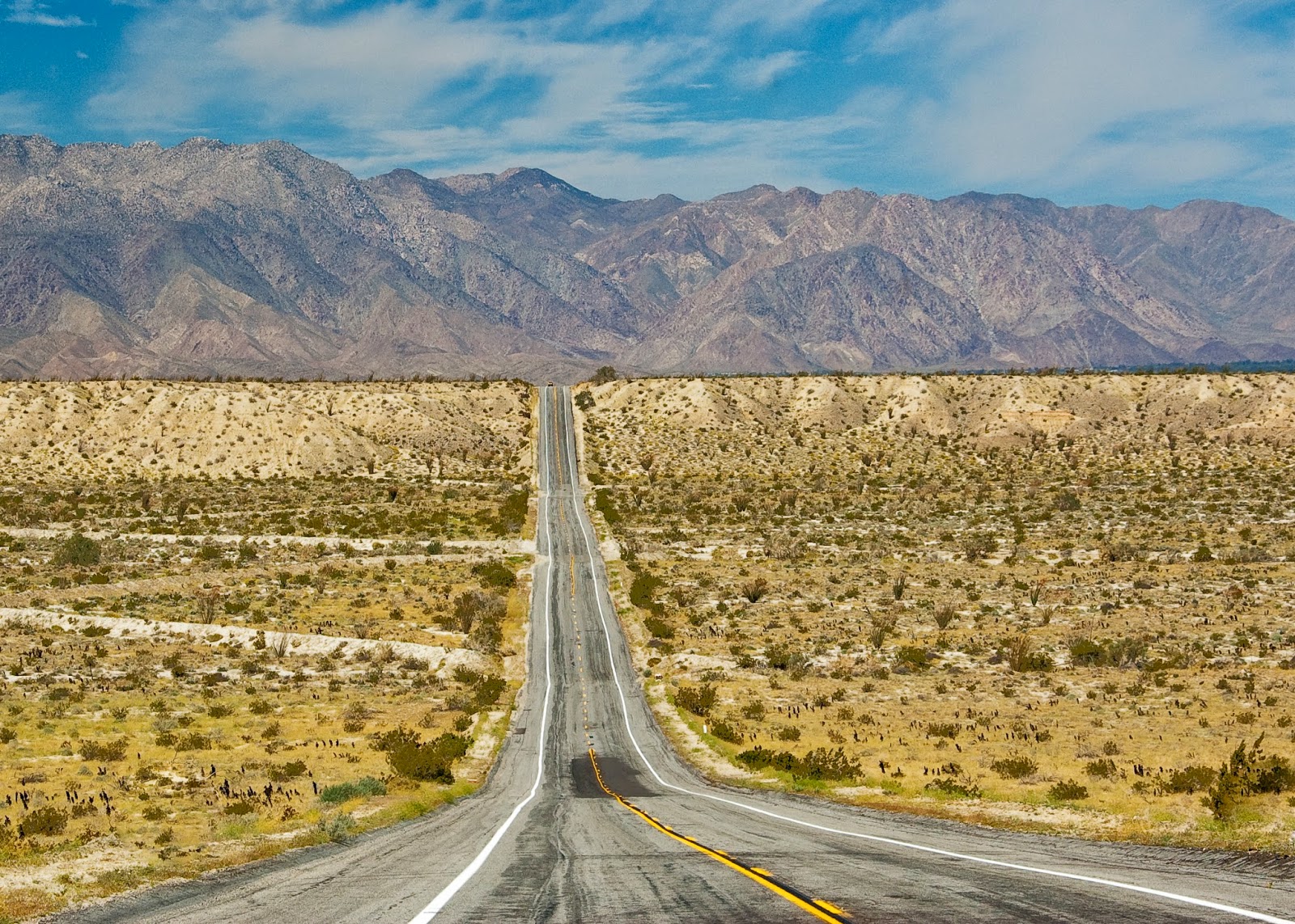
Highway dips are usually worth a stop and look.

This big one, known as "The Texas Dip" , is located outside Borrego Springs near the CA-78/Borrego Springs Road junction..  The San Felipe Wash "flows" through here.


This dip is located in the Sierras, just west of Coulterville on CA-132.


***

Know of any good dips?

Saturday, March 29, 2014

Wildflowers 2014

by Steve Reiss (Dalmdad Landscape Photography - www.dalmdad.com and https://www.facebook.com/Dalmdad.)

We backroad explorers typically look forward to wildflower season (aka "spring"). When we had a wet winter and a continuing wet spring, our back roads (as well as main roads) become lined with the ROY G BIVs of the floral world.

In 2009, during our early years in southern California, there was an explosion of purple verbenas of various types along Henderson Canyon Road near Peg Leg Road, outside Borrego Springs.


*

2009 full ocotillo blooming.  Here, not only are the flowers blooming, but green is lining the branches.


****

Come 2014, wildflowers are not too widespread.  I was lucky enough to happen to see some ocotillos blooming on the S-2, between Ocotillo and Scissors Crossing.  However, all we get to see are the fierce thorns and the red flowers.  


Tuesday, July 30, 2013

Irony and Pain in the Cactus Patch (reprint)

by Steve Reiss (Dalmdad Landscape Photography - www.dalmdad.com and https://www.facebook.com/Dalmdad.)

If you have not had a chance to read our April 15, 2013 blog post at desertusa.com about my being attacked by a cholla ball, we reproduce the story here for your reference....

***

I have been to Anza-Borrego Desert State Park quite a number of times since I discovered it, back in 2008.  OK…not “discovered” as in the Juan Bautista de Anza sense.
On Saturday, April 6, 2013, I went to ABDSP with the primary goal of spotting wildflowers.  Its still a little early to see Bighorns roaming around.
Reports are 2013 has not been a good year for wildflower sightings.  What flowers there are, are not visible directly from any of the park’s roads; you had to get out and walk a bit.  One place where flowers were reported to be, was Grapevine Canyon.  I had never been in the Grapevine Canyon.  The ABDSP Travel Guide (Lindsay 2006) says that Grapevine Canyon has the “largest, densest, and most varied displays of succulents.”
grapevine-2-52
grapevine-2-1185

Ocotillo in the background; teddy-bear cholla in middle; silver cholla in foreground


Grapevine Canyon Road (GCR) is not as much road a a dirt and rock trail.  It begins behind the Tamarisk Grove Campground off of Yaqui Pass Road and passes between the diverging (or converging, depending on whether you are traveling east or west) CA78 and the Pinyon Ridge. Grapevine Canyon Road partially coincides with the dry wash of San Felipe Creek.
So, I turned west off of YPR, traveled through the Tamarisk Grove Campground, and then between the think brown plastic markers that identified the beginning of the GCR.  Bumping, rocking, shaking, and twisting my way down the road, I saw campers (vehicles) parked along the road-side campgrounds.  However, no actual campers were seen.  
Though GCR is rugged and remote; remarkably, you are never out of sight or sound of Highway 78.  Indeed, there was some kind of law enforcement action going on over the 78.
In most spots, the trail is one narrow lane.  At one point, an SUV was coming eastward, towards me, and the road wasn’t wide enough for the both of us.  I started to back up to find a camping spot where I could back in.  Fortunately, the driver of the other SUV, pulled into a side space before I could and he allowed me to pass.  We gave each other that friendly wave that says had we been anywhere else, we would have ignored each other.
At some point the blooming cactus colors began and I decided to take some shots.  No, not do shots, but take some (i.e., pictures!).  Interestingly, doing shots would have reduced the pain I was about to be inflicted (afflicted?) with.
There was plenty of space between the plants, mainly: teddy bear cholla, ocotillos, prickly pear cactus, barrel cactus, and assorted others.  For about 10 minutes I was snapping away.  The sun was strong (I was wearing my hat), but there was a nice wind.  This area was far cooler than the area of the park’s Visitors Center, which is at about 1000 feet lower in elevation than the Grapevine Canyon.
I was looking through the camera; straight down, at a cholla flower, and I could see through the viewfinder that my camera strap was blowing from the wind into the frame.  So, I tried to flick the strap out of the way.
The strap hit a portion of the cholla and the cholla, as cholla are prone to do, it stuck to the webbing of the strap.  No biggy, I just tried flicking the strap so the cholla would land on the ground somewhere.
grapevine-2-1178
BUSTED!  As great plans often go to @#$!, so did this one (though maybe it was not such a great plan).  Next thing I knew I felt the pains on this unfortunate cholla landing zone…
As stupid as it seems after the fact, the first idea I had was to just try to grab the cholla ball with the other hand to remove it.  The instant pain…now in the right hand as well as the left arm, reminded me just how stupid the plan of grabbing the cholla ball actually was.
Standing there alone in the sandy wash and surrounded by hundreds of these cacti, I did feel a sense of dread.  I was not exactly sure what to do next and I was not going to take this ball of pain into the car.  So, even though less than two months ago I had posted in an article about chollas on my own blog including videos of people removing cholla needles from their skin (as comic relief), I don’t think I actually watched the videos so I did not know what they did, other than say use tweezers to remove individual spines.
Though I usually don’t carry a knife with me when I am out, I did today.  I opened it up and began trying “Scrape” the ball off.  This did hurt and you could see the skin being pulled upward as the knife tried to separate the spines from my arm.
2013-04-14 13.40.09-1
The cholla ball finally came free only to get stuck on my boot.  But, that was a pretty painless removal.
grapevine-2-1180
grapevine-2-1184
Two Days After Removal
 grapevine-2-1188
Five Days After Removal

grapevine-2-1190
Six Days After Removal
***
And now for the wildflower pics…
DSC_3505Hedge-Hog Cactus
DSC_3537
Agave
DSC_3523Dead and Budding Hedge-Hog Cactus or Nest and Cactus - Not Sure  DSC_3505Hedge-Hog Cactus
DSC_3530
Silver Cholla

Sunday, October 28, 2012

Backcountry Falls - Not What You Might Think

by Steve Reiss (Dalmdad Landscape Photography - www.dalmdad.com and https://www.facebook.com/Dalmdad.)

A fictional tale about nature's order...

I remember that day vividly and horrifically. It was my saddest day ever in my 25 years as a park ranger.  

I was far into the rugged back country of the park (Anza-Borrego Desert State Park).  At Anza, I had packed and mounted my horse, Anzanita.  We then continued southward about 10 miles on Coyote Canyon Road to the area known as Turkey Track.  Turkey Track is ridiculously unstable (especially after rains), has sharp drop-offs, and ledges narrow and covered by loose slate or mud after storms.  Though the Track is open to true 4WD vehicles; I mean the type with high clearances, low gears, and wheel lock-outs, park guide books unanimously emphasize just how 'bad' this road is.  Practically, the Track is really only accessible by horseback riding, hiking, mountain biking, and burro trains.  Between Upper Willows and Middle Willows, where I was when it happened, is closed to all vehicle travel.  This three mile stretch is prime bighorn sheep watering areas.

The sounds of rocks sliding and falling does not take a park ranger with 25 years of experience to identify.  As I looked towards where I heard the rock slide, what I saw broke my heart.  I quickly grabbed my binoculars to double-check. I was right.  Rolling down the rocky and wooded hill was one of the park's bighorn rams.  Also rolling down the hill, following the ram, was a mountain lion.  Through my binoculars, I saw another mountain lion cautiously watching from the ledge as her mate and what I assumed to be their intended meal rolled down the hill.

All this was happening on the other side of Coyote Canyon and it would take me a while to get to a point where I could cross Coyote Creek at a shallow, slow flowing part and then backtrack to the point where the animals fell.  I recorded my coordinates on the GPS and started walking, leading 'Zita by her reins.  The animals on the other side of the canyon would surely be DOA by the time I reached them-  if not dead already.


***

Back at Majanga Spring, way up on Majanga Flat, we all looked up from drinking.  We heard the noise and the older among us knew what it meant.  I looked around.  Old Biggy and Smitty were not with the herd. They were known to randomly go out and butt heads, though Smitty conceded Old Biggy's dominance within our herd.


I sent out a call and Smitty's long yelp answered, but there was nothing returning from Old Biggy's drawling accent.  We all thought we knew exactly what happened.  Slippage is a risk we face every day as we move further and further uphill to protect ourselves against those predators with the guts to follow us.  We are typically the only ones that can make their way up so high on loose rocks and into protection.  But the higher we go, the greater the risk.  Indeed, when I was younger, I took a short slide down a steep canyon wall.  


It is a risk we all knowingly take because that is how we survive. 

***

I had finally reached the 'drop zone', for lack of better or more euphemistic term.  I released a couple of shots from my Browning rifle into the air to scare away any circling vultures, hiding coyotes, or surviving mountain lions to clear the area for my safety. 

The mountain lion's body was in much better shape than the ram's, though the mountain lion was just as dead as the ram.  The mountain lion just rolled down the hill, but the ram horns violently whipped the ram's head around, got caught on branches, and bounced the poor ram's head off rocks. What was left of the horns would not be going on display at any nearby museums and the ram's neck was obviously broke.  I guessed the ram died about 1/3 the way down and the mountain lion died on impact with the ground.

I opened a saddle bag and took out a small laser bar-code reader.  Luckily for me, this ram did not lose its collar on the way down.  I scanned the bar-code on the collar and a code showed up on the display.  The code meant little to me out here in the field.  The rangers at Park HQ in Borrego Springs kept track of the animal database.

I walked around trying to find a clear area out from under the tree canopy.  I found a spot and called park HQ on the sat phone.

"Hernandez, Animal Monitoring."

"Pico?  Flack here."

"Flack, you safe, mi hermano?"

"Yes.  I am at the spot."

"You made good time."

"I guess brother..."

"Does he have an ear tag?"

"No. He barely even has an ear.   Just a collar."

"OK.  Let me pull up the database.  Code?"

"C-O-0-1-7"

"An oldie.  Hmm.  'Old Biggy'...17 years old... born in-park...Parented three rams and two ewes.  Last vet check was about 6 months ago by Dr. Floyd."

"He looks pretty bad; the severe horn damage from the fall, some vulture feeding, and a broken neck.  I'm guessing the mountain lions chased him and these two took a nasty, unintended slide down a soft edge."

"OK.  I will prepare his file for closure when you get back.  Don't forget to take blood samples and of course the tracking collar.  Oh might as well take blood from both animals.  I will give you a break and not ask for a fecal sample."

"Muchas gracias on the fecal.  I will mark the coordinates of the site, post a marker, and take some pictures.  No reason to bury or extricate the carcasses.  I will leave them to the vultures; they have already been munching away."

"Remember its the natural order of things."

"I know"

"Be safe, hermano."

"Gracias."

I stood there looking at the two carcasses and I gave them what I thought was a proper blessing.

***
I slowly --carefully-- walked towards the edge of the cliff where my father slipped and fell to his death trying to escape from a mountain lion.  I laid down and looked across the valley.  My nose suddenly picked up the smell of a ewe.  I turned around and it was Santia, the alpha-ewe in our herd.  She walked over to me and hit my snout with hers.  That told me everything I needed to know. 


The New Alpha-male


Thursday, September 13, 2012

Spotting our favorite desert creatures...

by Steve Reiss (Dalmdad Landscape Photography - www.dalmdad.com and https://www.facebook.com/Dalmdad.)

September 7, 2012: Near Yaqui Pass, Anza-Borrego Desert State Park, California 


I tend to go on-and-on about how Anza-Borrego Desert State Park is a great spot to see bighorn sheep.  We hoped to see at least one on our way down Montezuma Grade, which as I have written before, is a prime bighorn observation point.  Indeed, in February 2009, while going up the Grade, we saw a huge bighorn ram watching over the valley.

February 2009 Ram Sighting - "King of the Desert"

This time, going down the Grade, however, we wound up seeing zilch and mainly only saw the fire damage from the late August 2012 wildfires. 

At the base of the Grade, we drove through deserted Borrego Springs.  This tourist spot was pretty dead and will have a totally different vibe come winter.  No, it won't be filled with ski-bunnies and snow-boarders.  But, with the winter temperature rarely exceeding the more tolerable 70F, the desert will be filled with hikers and off road vehicle drivers. Now, it is just still way too hot for anything.

At Christmas Circle, we swung south out of town on our way to Julian.  Yaqui Pass is another place to spot the bighorns.  However, as the pass is quite tight with almost no places to pull over, photography is difficult.  We did spot a ram and ewe in this general area back in November 2008.


November 2008 Ram and Ewe Sighting

Now, I was sitting in the back seat of the truck, with Joanie and her mom sitting upfront when Joanie let out an "I saw one" scream.  Of course, by that time, we went through an S-curve that totally blocked our view of the bighorn.  So, at the base of the hill, she stopped, I took out my camera and the biggie lens and got back in the truck.  It was hot and dusty out and the "closed for the season" campground had a sign warning that the closest open bathroom was in Borrego Springs.

We headed back up the hill, with no bighorns in sight.  At the first turn-around, that is what we did, and we crawled down the highway, much to the chagrin of aggressive motorcyclists. 

We finally spotted the ram way up on a ledge.  How Joanie sees these things is incredible.  We pulled over the best we could and I snapped away.  Even eyeballing the ram way up on the ledge, we could see it was with an ewe.  Between the idling truck, my unsteady hands, and the difficulty of hand-holding a 600 mm lens, I was kind of down on the whole sighting and not expecting much from the pics.  I raised the ISO of the camera to 1000, hoping for a sharper pic.

As with the earlier ram sighting described above, these bighorns were in a terrible position for photographing; back lit.  Post-processing the images to bring out the details made the colors somewhat unnatural, so I converted them to b&w.


September 2012 Ram and Ewe Sighting


September 2012 Ram and Ewe Sighting


September 2012 Ram and Ewe Sighting - View showing how close to the edge these guys can get!


September 2012 Ram and Ewe Sighting
***

Just as we pulled away to continue down the hill we were pulled over by a heavily armed, well armored cop of some type (there is a heavy Border Patrol at certain parts of the park).  He reminded us that pulling over in this area was very dangerous (yeah), but let us go without a ticket.

Next stop was Julian and some ice cream.

For those keeping track or out looking for the bighorns on their own, here is a summary of our sighting locations and good places to start your search.


Tuesday, May 22, 2012

King of the Desert?


by Steve Reiss (Dalmdad Landscape Photography - www.dalmdad.com and https://www.facebook.com/Dalmdad.)

Tradition says the lion is the "king of the jungle."  Other traditions go even further and say the lion is the "king of all beasts".  While I may accept that “king of the jungle” stuff because I do not live in the jungle, I object to the characterization that the lion is king of all beasts. The lion is certainly not the "king of the desert."  I am the king of the desert! Who else could hold such a title?  A chuckwalla?  I think not.

 Chuckwalla...King of the Desert? Not quite.

Gila Monster...King of the Desert? Scary name and venomous...  Maybe, but nah!

We are the few able to climb up the steep unstable walls of the desert valleys and sit up on the rock perches far above the road.  Sometimes we will look down on you or, on other occasions, we may flat out ignore you and look over our desert. 
 King of the Desert!  Male Bighorn Sheep (Ram)

Coyotes can't reach us; cougars can’t reach us; you humans certainly can’t reach us.  But, I can tease you all with my stoic downward looking gaze.  My huge curling horns (sometimes weighing more than 30 lbs.) and expressionless face may give you the impression that I exist for the sole purpose of you photographing me.  However, to make it clear who is in charge, I frequently make taking my picture extra difficult by sitting up on the rocks with the sun to my back, placing me in a dark, cool shadow.

Montezuma Grade, the road leading down into and up out of the Anza-Borrego Desert State Park Valley Floor is a popular place for us to roam around and be seen.  Our other grazing and watering areas near Lower Willows in Coyote Canyon are much more remote and closed to vehicle traffic.  At a pull-off about half-way down the grade and looking due east over the entire Anza-Borrego valley floor and toward the Salton Sea on the horizon in the distance, I have seen some kind of board with a picture of one of my distant relatives on it.
My Typical View From Crawford Overlook on Montezuma Grade..Salton Sea and Glamis Sand Dunes at the Horizon

I cannot read the native language of the writing of the board, but I am guessing the board is a sign telling the reader this is ovis canadensis (big horn sheep) territory.

I am forced to wear a green collar.  I did not get to pick the color or approve the placement of the collar on me.  I would have shown my disapproval to its placement on me by gently nibbling or firmly biting, if the need be the fingers of the ranger who collared me.  However, the ranger drugged me from a distance with a chemical dart shot from a rifle a distance away.  The ranger lacked the guts to try and approach me and drug me directly. 

Note: Gila Monster drawing from Wikimedia Commons.